Crerar-Lawn Homepage

Thursday, June 05, 2014

Running the West Coast Trail in One Day


2011 UPDATE

Our team of adventurers has just returned from a glorious one-day run of the WCT, myself for a second time. A few more thoughts on the run to add to the article below.

How to cross the Gordon River?

1. Pay Butch Jack, who has a Parks Canada-anointed monopoly over the river crossing, a(n expensive) premium for a special late pick-up. You will have a very difficult time persuading anyone else in Port Renfrew to stir up local trouble by agreeing to ferry you across, or rent you a boat, especially in advance via telephone.

2. Swim across. The water is a little cold, and there may be some minor boat traffic. Google images of Gordon River to get a sense of the 150 metre-odd distance.  We crossed at low tide in August, when the river was low and calm, with no problem.  If the tides or weather or currents are not as perfect, you will have to use your judgment. Photos of the crossing here and here, and an account of some swimmers here.
Swimming hints:
  • empty out your hydrapack running bladder. Then inflate the bladder through the hose. Instant flotation assistance!
  • Bladder also doubles as a wet-bag to keep items dry (although I'd recommend getting a dedicated wet-bag for high-risk items like your camera and smart phone).
3. Have a non-running friend ferry you across in a two-man kayak or canoe.

4. Bring a non-running friend along. The day before your run, take the last Butch Jack ferry across the Gordon River. Hike in and camp overnight at Thrasher Cove or on the trail above it. In the morning, you run the trail north to Bamfield, and the friend takes the camping supplies and the ferry back to Port Renfrew. A group of female runners did this recently.

5. Best and simplest method, which we thought of too late:
a. run south (Port Renfrew)  to north (Bamfield).
b. buy and bring a cheap $30-$99 2- or 3- man inflatable boat.
c. cross Gordon River at 5AM-ish (access via the trailer park beach)
d. leave boat at south trailhead with a sign marked "free". Some happy hiker who misses the last Butch Jack ferry of the day will appreciate it.
e. running S to N has the added advantage that the last 12K (Michigan Creek to Bamfield) is the easiest, and least scenic portion of the trail, so better to do in the night if you need to.

Orientation
Parks Canada confirms that the orientation powerpoint presentation is now mandatory: it used to be optional for anyone who had hiked the trail before. This rule is annoying and inconvenient, as the orientation is only offered at certain hours (e.g. 3:30 pm), and as anyone who is learning for the first time in the orientation session the information provided (e.g. do not feed bear cubs) should not be on the trail in the first place.
That being said, runners should not endanger the ability of future others to run the trail by making a fuss: just catch an earlier ferry.

Permits and reservations
Day-runners are required to buy the $127 "overnight pass" even though they are not overnighting.
The good news: runners do not need an advance reservation.
Again, do not argue or make a fuss: the fees are in theory for a good cause (trail maintenance) and you don't want to deprive future runners of the ability to run the trail by being a jerk.
You also need to buy passes for the ferry boats ($16 each). For those tempted to roll the dice, the ferryman DOES check the passes and you would be most bitter to be turned back halfway through, at Nitinat Narrows. Swimming is not an option at Nitinat Narrows, where crazy currents drown men and scuttle boats.

Must-dos
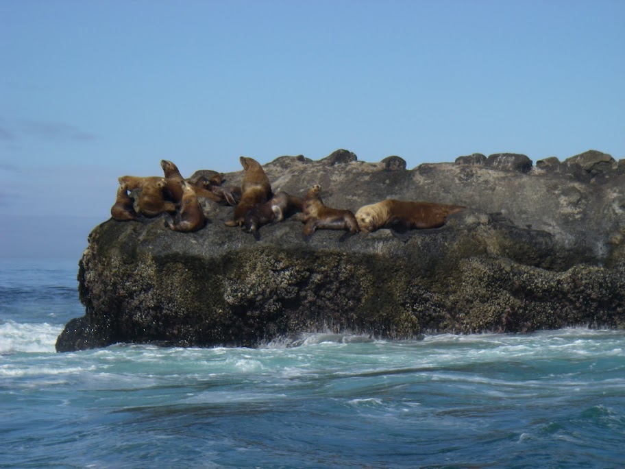
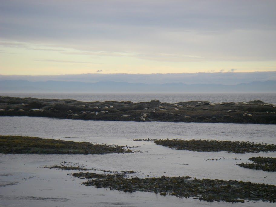
1. instead of the West Coast Express Bus (which is otherwise a perfectly fine service), take Brian Gisborne's water taxi back from the end of the hike to the beginning. He took us to see much wildlife: about 30 killer whales; 5 grey whales; 2 humpback whales;hundreds of sea lions; jumping porpoises, etc. Stunning. $135: only $40 or so more than the bus.
2. Contrary to what you read elsewhere, do the Owen Point ocean route if tides at all permit: cavessea lion island, rock climbing, waterfalls, sea stacks, surge channels,sandstone shelves from Mars: one of the most gorgeous stretches of this gorgeous trail.

Friday, June 13, 2008

Running the Flores Island Wild Side Trail

Running the Flores Island Wild Side Trail
Runnable shell-strewn beaches alongside old growth forest and past bloody battlesites


David Crerar
June 2008


Most of us already know the west coast of Vancouver Island, particularly the Pacific Rim National Park, as a trail-running paradise. On June 3, 2008 I discovered an extension of that paradise, on the 28K out-and-back beachside Wild Side Trail, on the south shore of Flores Island, about one hour northwest of Tofino by water taxi.

Despite its location, it is readily and cheaply accessible from Tofino: throughout the day, water taxis scurry back and forth between Marktosis/Ahousaht (the two towns of Flores Island) and Tofino at the bargain price of $16 each way (in contrast to the approximately $100 a head paid the weekend before for a shorter water taxi trip to the North Coast Trail trailhead from Port Hardy; to be fair, the $16 taxis must be significantly subsidized by the Federal Government).
The trail consists of some eight sandy beaches, all of them runnable, interspersed with brief interior trail runs, again, all very runnable. The run culminates in the most spectacular beach of all, Cow Bay. An additional 8K (return) can be added by running up Mt. Flores (860m) from Cow Bay. For ultra-marathon purists looking to round out the additional distance, apparently there are additional trails heading southwest from Cow Bay to Siwash Cove (but be prepared to bushwhack), or various interior logging roads. Or just savour an additional out-and-back along Cow Bay’s spectacular 4K sweep.

The trail is easy, flat, well-groomed, and well-marked. It would lend itself well to a solo run, or an adventure with a non-running significant other. While easily done in a day, a multi-day sojourn would be a very pleasant holiday. You will likely have the entire trail, or at least an entire golden beach, to yourselves.

When I had mentioned to two Tofino locals in the tourist trade that I planned to visit Ahousaht for the trail, their faces visibly blanched and both told me that I shouldn’t go because it was “dangerous” (their words). I am happy to report that while Ahousaht isn’t Kitsilano, all of the townsfolk I met were very friendly, and based on my limited experience, the warnings were wholly unwarranted.

The adventure starts at the Tofino Government Dock at the foot of First Street. The Ahousaht Pride water-taxi departs Tofino daily at 10:30am and 4pm (and back from Marktosis/Ahousaht at 8:30am and 1pm). This schedule would not provide enough time for the run, so I called other Ahousaht water taxis. During school months the Rocky Pass (1-888-726-8427) taxi usually leaves at 7:45am to shuttle teachers to the Island, returning at 3:45pm; this was the option I took. At the end of the day, I arrived back to Marktosis with 45 minutes to spare. The band office kindly radioed various water taxis; we discovered another taxi was heading back early, at 3pm, so I hopped on that one – the point is that despite its semi-remote location, a bit of digging can probably net you a full day on the island, without having to personally charter a boat.
The water taxi (piloted by Bill from Ahousaht : “Laundry bill, phone bill – however you want to remember it”) travels past the volcanic cones on Meares Island and Cat Face Mountain, and past countless coves and rocky islands and promontories, before landing at Marktosis (Maaktushs), the main town of Flores Island, nestled within a cove within Matilda Inlet, at the southeast corner of the island. A few houses south of the main dock is the band office, in a two-story reddish wooden building, where one stops to check in and to buy the $20 trail permit.

The town ends four or five houses to the south. The main road out soon forks: take the smaller, left, road. Soon you come to the “Walk the Wild Side” trail sign, slightly obscured by the scotch broom which lines the first half-kilometre of the trail, at times forming a narrow arch. A heavy storm had soaked Clayoquot sound the night before, and within 10 seconds I was wholly drenched from the foliage. At the trailhead, two large piles of bear scat greeted me (although no further evidence of bruins was seen).

A boardwalk path travels over a boggy section known as 7a7ukwnak (“It has a lake”). A sign indicates was a significant site of the fourteen-year Ahousaht -Otosaht conflict in the early 19th century, during which the Vargas Island-dwelling Ahousaht defeated the Otosaht people resident on Flores. Such signs are found throughout the trail, adding an element of drama and at times chills to the run. In addition to a brief description of the historic significance of each site, they all feature aboriginal designs carved by Stanley Sam Sr., an Ahousaht elder, and painted by his son, Hutch Sam.

The boardwalk in this section is typical of the boardwalks in the trail: cut whimsically in undulating and uneven shapes, in contrast to the Parks Canada standard widths. Despite the constant showers and omnipresent moss, the boardwalks were, surprisingly, not terribly slippery.

The boardwalk leads to a brief forest interlude and the first beach, where legend dictates a giant octopus resides. The receding tide left hundreds of juvenile octopi, looking like little lumps of flesh from a horror movie, strewn over this beach. The beach is also known as Stinking Beach, and it lived up to its name. At this beach I was joined by two local friendly dogs who tagged along for the next 3K or so.

A brief forest interlude features more whimsical boardwalks and a sign recognizing the trail construction by members of the Ahousaht Band and the Western Canada Wilderness Committee, before exiting onto the first beach of Whitesand Cove. In the sand dunes above the beach, there is a wolf-warning sign and an outhouse. As is typical of all beaches on the trail, the headlands extend into the sea as chains of small islands. Bald eagles soar overhead. Sandpipers skitter along the shore, pecking for food. The beaches are strewn with giant Washington clams, impressive Lewis’s Moonsnails, and countless other shells.

A trail located halfway down Whitesand Bay leads to the town of Ahousaht, by way of the Ahousaht warm spring, at the southern tip of Matilda Inlet. There is apparently a concrete pool for bathing in these tepid springs.

At 5K the trail proper continues inland, along the “Trail of Tears”, again a site of bloody encounters during the Ahousaht-Otosaht war. If the tides permit, it is better to avoid this boggy stretch and stick to the beach which, like the other beaches, offers beautiful runnable sand. The best part of the Trail of Tears is the sign at the start of this stretch, under a giant cedar, marking “Katkwuuwis”, which apparently translates as “Cut People’s Heads Off”, again, a historical reference to the war. As I ran the trail, bowing down to avoid windfall and bushes, I occasionally thought that I’d look up to become the next decapitated victim.

A wide creek exits at about 6K, to the west of Kutcous Point. A rough trail travels through the forest on the east side of the creek. Alternatively, it is possible to scramble along the creek shore. Both routes end at a metal bridge which marks the end of the Trail of Tears section.

On the west side of the bridge the loud drone of a hummingbird flitting among the salal punctured the air. This creek crossing was the site of the fiercest battle of the Ahousaht-Otosaht war, with many deaths at this spot. A sign proclaims that at this site “Keltsomaht war chief Tl’ihisim, a man named Wiittlaakinish and a man named 7aya7aktl’, wounded an Otsosaht sharpshooter ‘Tlihuumalhni’”. Alternative routes go southwest around the peninsula or northwest over land. The northwest route immediately takes you through a rooty tree cave and as I passed through I hoped that I would not meet the vengeful spirit of the Otsosaht sharpshooter.

At the next beach, again beautiful, is a shelter that appeared to be inhabited. At this point I made the mistake of skipping the beach trail exit halfway down the beach, as marked by hanging buoys. Instead, I scrambled along the headlands, resulting in the discovery of a two beautiful tiny coves between the headlands, but leading to an hour-long scramble over the oft-slippery rocks with a few bushwhacks along bear trails. Eventually I punched out at a creek at the east terminus of the spectacular Cow Bay. The proper trail, as I discovered on the return, is a pleasant forest trail crossing the creek over a felled sitka spruce log bridge.

The Cow Bay waters are clear, the surf loud, and the views stunning. The waters are clear; the cove is dotted with rocky islands. Cow Bay is apparently an important feeding ground for gray whales, although I saw none. Here I saw the only other people on the trail, who had decided to camp for a few days at this paradise, just west of the wooden hull of a shipwrecked boat.
The run along the perfectly-curved bay, over sand of perfect consistency, was euphoric. At the end a short trail travels up a narrow gully through the headland, leading to another lovely beach. At the end of that beach the trail continues up Mt. Flores. That trail, like the Wild Side Trail, is at first well marked, with flagging and blazes. Unfortunately, the twisting trail, coupled with deadfall, and the thick spring undergrowth, eventually made that trail impossible to follow. With an eye to the time of the return water-taxi, and the fact that the clouds made views impossible from Mt. Flores, I pulled the plug at about 18K, at a log covered in tempting oyster mushrooms. No sooner had I done so, but I lost the trail again, leading to a half-hour bushwhack in which my legs were slashed by the undergrowth. Before hitting the beach again, I lost the trail a second time. Let my haplessness forewarn you that a GPS would be advised for this section (although it is not necessary for the Wild Side Trail proper).

Massive old-growth cedars and hemlocks festoon the Mt. Flores hike, along with the entire Wild Side Trail (particularly along the Kutcous Point Creek).

Given a conservative allotment of time, I was able to walk back for much of the return trip, savouring the beauty of the beaches, and the ingenuity of the trail-builders. Out of nowhere, the sun came up, recasting the grey of the beaches on the out-run into a golden return.

Background materials

o Philip Stone’s Coastal Hikes has a detailed write-up of the hike, as well as excellent write-ups of 12 other coastal hikes: http://www.wildisle.ca/
o Stanley Sam Jr., Ahousaht Wild Side Heritage Trail Guidebook (Western Canada Wilderness Committee, 1997; out of print)
o John Kimantas’s The Wild Coast, Volume 1 is a superb and encyclopedic survey of every explorable nook and cranny on the north and west coasts of Vancouver Island

Photographs
http://www.flickr.com/photos/8661048@N07/sets/72157605505672737/

Labels:

Running the North Coast Trail

http://www.clubfatass.com/blog/david-crerar/running-north-coast-trail


Labels:

Sunday, October 15, 2006

Initial entry

Just a test